The National Monuments Service of the Department of Culture, Heritage and the Gaeltacht has unveiled further stunning photographs of newly discovered archaeological features across the Boyne Valley landscape and Brú na Bóinne World Heritage Site. Six of the sites are featured below. The Minster Josepha Madigan TD commented interestingly:
The results, which are still being analysed by the National Monuments Service, are simply awe inspiring. It will take some time to fully understand the place and relevance of these archaeological features and to comprehend the scale of what was clearly a very advanced civilisation.
Today, I am putting some further images into the public domain. These illustrate the secrets this landscape has held for thousands of years and which the recent spell of dry weather has revealed for us.
This investment in the past will inform many generations of archaeologists, scholars, historians and indeed the broader public understanding of where we, as an island nation, came from and indeed the possibilities of where we could go. Illuminating our past and our ancient landscapes, these shadows, cast by our forebears from thousands of years ago, fall gently on our shoulders, just as we stand on the shoulders of those who built these monuments.
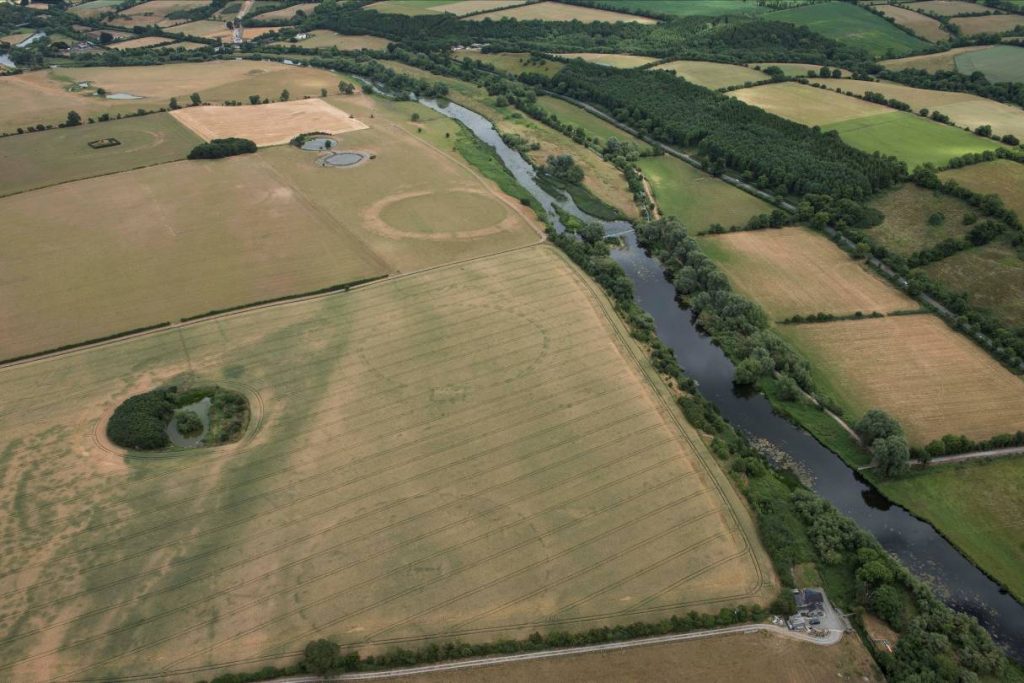
Image 1 –Newgrange and the Brú na Bóinne floodplain

Aerial view of the Boyne floodplain to the south of Newgrange passage tomb.
From 5,000 years ago Neolithic farming communities built a range of impressive monuments across this landscape that is designated as the Brú na Bóinne World Heritage Site by UNESCO.
Recent discoveries will transform our understanding of this archaeological landscape.
(Photo: National Monuments Service)
Image 2 –A designed Neolithic landscape
View of three henge monuments on the River Boyne alluvial terrace south-west of Newgrange passage tomb.
The photograph dramatically captures the configuration of three large circular ceremonial enclosures (diameters range between 130m to 200m).
This use of space for ritual gatherings and religious celebrations indicates a conscious use of space by the builders.
The arrangement of the three massive henge enclosures suggests that the construction and use of all three may have been conceived as a single design. These henges are likely to date to the late Neolithic around 2900 BC.
(Photo:National Monuments Service)
Image 3 – The ‘Geometric Henge’

High contrast image of newly discovered henge at Newgrange.
Discovered by Anthony Murphy and Ken Williams, this enclosure displays a remarkable and sophisticated geometric design. The evidence obtained raises many questions in terms of its function and form.
Adjusting the high-resolution digital imagery has sharpened the contrast of the cropmarks of the buried features, allowing greater appreciation of the geometric design and layout of the enclosure.
Two concentric rings of post-holes surround the inner enclosure formed by a series of segmented ditches. An elaborate series of ditches and post holes in a rectangular setting can be seen at the bottom of the image while the projection at the top is likely to mark an entrance feature.
(Photo: National Monuments Service)
Image 4 – Newgrange henge complex at Site B

Another newly discovered group of henges south-east of Newgrange passage tomb.
Located on the lowest terrace of the floodplain south of the Newgrange passage tomb, a pair of henge or ritual enclosures is located close to a mound which is thought to cover a passage tomb (known as Site B).
A smaller circular cropmark in the foreground depicts an enclosure which is also likely to have had a ritual function.
At well over 100m in diameter, the scale of the large enclosures, each marked by cropmarks indicating a wide bank and a well-defined outer ditch, is evidence of the communal effort and resources that would have been required in their construction.
As gathering places they would have provided large arenas for ceremonial activities.
(Photo: National Monuments Service)
Image 5 –Prehistoric timber post enclosure

Prehistoric enclosure south of Newgrange passage tomb.
About 500m south-west of Newgrange passage tomb, this high resolution image shows a double ring of post-holes about 30m in diameter enclosing an arrangement of four huge post-holes with entrance features to the east.
The entrance is enhanced by two parallel lines, probably also once marked by large timber posts.
The image also shows markings indicating an outer enclosure, around 80m in diameter, enclosing the smaller features. The site might have served as a mortuary enclosure.
(Photo: National Monuments Service)
Image 6 –Prehistoric ritual roadway or massive enclosure?

The image shows cropmarks indicating the presence of palisade trenches (c. 25m apart) curving around the mortuary enclosure.
The extent and function of these features are particularly intriguing.
The parallel linear features form an arc that can be traced for a distance of c. 200m across the field of crops. If the arc is part of a circular enclosure, it would be of a massive scale, almost 400m in diameter. Alternatively, these features may form part of a processional routeway leading to the terraces of the Boyne River floodplain and its henges.
(Photo: National Monuments Service)